If you are considering a development on your land or property, one of the most obvious issues to overcome is how to provide access to it, and this is just one of the many aspects of a planning application that we can assist you with (with a little help from our friends, who are more qualified in this field!). In this article Stephen Flacke (BEng (hons), CEng, CMIHT), Director at Egg Transport Planning, has kindly outlined some of the key things to be considered when you are looking at accesses and visibility splays so that we can share them with you.
Firstly, it’s worth noting that not all new accesses require planning permission. Planning permission is not usually required if the access will be located on an unclassified (minor) road, it is normally only needed for ‘A’, ‘B’ or ‘C’ roads. Even if the road is unclassified, the local highway authority will need to be consulted to ensure that the access is safe (more on this below) and to ensure that it is constructed so that it can protect any services buried in the ground, such as water or gas pipes.
Planning policy requires that a proposed development must provide ‘safe and suitable access for all users’, but what does this actually mean? Let’s take a simple example, where a landowner wants to create a new access.
It is paramount that the access will provide adequate visibility for drivers to use it safely. In simple terms, this means that a driver emerging from the access needs to be able to judge if there is a gap in passing traffic which will let them pull out safely and avoid a collision.
An emerging driver needs to able to see for certain distance either side of the access, are these areas are referred to as visibility splays. The splays are normally measured from a point which is set back 2.4m from the notional ‘give-way’ line (referred to as the ‘X-distance’), as this represents the distance between the front of the bumper and the driver’s eye line. The distance required either side of the access (referred to as the ‘Y-distance’) is dependent on the speed of passing traffic, and the faster the traffic the longer the distance.
The diagram below is taken from a guidance document, called Manual for Streets and shows how to draw the visibility splays.
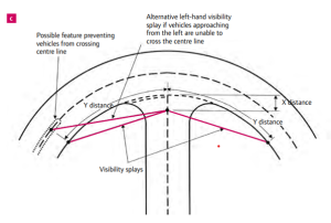
Source: Manual for Streets
The Y-distance is normally measured along the kerb line on the side of the road where the access is to be located. It’s important that the visibility splay only crosses land which is under the control of the applicant, or land which forms part of the public highway. If it crossed 3rd party land then there is a risk that objects such as fences or structures could obscure the visibility splays and make the access dangerous. This would be beyond the control of the applicant, and the Council, as part of the scope of the application.
There are two sets of standards that are used to determine the Y-distance, one for streets with lower speeds and another for higher speeds environments, which is much more onerous. Here’s where it gets a little bit complicated (and why you may need speed surveys as outlined below!).
For a road with a 30mph speed limit, the required Y-distance is 40m (although some transport practitioners mistakenly use 43m). For roads with a 40mph speed limit, the Y-distance is normally 120m in each direction; for roads with a 50mph speed limit, the Y-distance is 160m in each direction and for derestricted roads (i.e., where the speed limit is set at the mandatory 60mph) drivers need to see a whopping 215m in each direction!
It’s often the case, particularly for derestricted roads, that the actual speed of traffic is much lower than the posted speed limit. If this is the case, then there may be potential to justify a visibility splay which is shorter than that required by the standards, but only if the speeds are measured properly.
If your proposal is likely to need highways support, we would always suggest you speak to a Highways Consultant who is appropriately qualified to support the proposal and ensure safe access for all users. As with any of the more specialist fields which come up in planning (such as, for example, ecology, trees, flooding, heritage or structural matters) we can put you in touch with one of our trusted specialist consultants who we have worked with previously on other projects.
If anyone has any highways related queries, or questions surrounding content within this article, please reach out to Stephen at Egg Transport Planning (www.eggtransport.co.uk) – we have worked with him on several projects with great success to date.